El Nino: A Weather Force Awakens
Monday, December 28, 2015

This year one of the strongest El Nino's of the past 50 years has developed. A number of studies have shown that the major impacts of strong El Nino are typically not felt over the West Coast until after approximately January 1. These impacts include wetter than normal conditions over California, a bit drier than normal over the Northwest, reduced snowpack accumulation over the NW mountains, and less chance of lowland snow.
After January 1, El Ninos tend to produce an offshore trough of low pressure (heights) over the NE Pacific and relatively higher pressure (heights) over NE Canada. The composite below 500 hPa heights (around 18,000 ft) shows the general pattern. This flow pattern tends to cause the Pacific jet stream to split, with flow going into California (black arrow).

The latest forecast models suggest that exactly this kind of transition is about to occur, with a major circulation shift that will dry out the NW and increase precipitation over California.
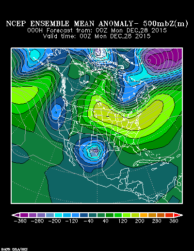
Take a look at the flow pattern anomaly (difference from normal) for 500 hPa for 4 PM Sunday (yesterday). Higher heights than normal over the NE US, lower heights than normal over the West Coast and higher height over the NE Pacific. Not very El Nino like.
But here are the forecasts for 5 and 10 days out. Huge change with low pressure developing over the Pacific. Shades of El Nino. A huge ridge over us on Friday in the first map...absolutely dry


Take a look at the total precipitation predicted over the next 2 weeks by the National Weather Service GFS mode. Heavy precipitation over CA (red colors), but hardly anything over Washington State and BC.

The latest Weather Channel ten day forecast for Seattle shows NO PRECIPITATION for over a week.


The El Nino force is strong with this one.
But the dynamics of a strong El Nino puts in motion changes that eventually destroys this feature. The latest central Pacific tropical sea surface temperature index (Nino 3.4) shows that this powerful El Nino has peaked and slowly declining.

And seasonal climate models (like the NOAA/NWS CFSv) indicates a rapid weakening of El Nino during the spring, with substantial confidence.

But El Nino will remain strong enough the second half of the winter for powerful effects. Next year will probably be a neutral or La Nina year, but it is too early to tell.
The bottom line: enjoy your skiing NOW. You should not expect the second half of the winter to bring bountiful snow like the first. Our reservoirs are in great shape with huge amounts of December water. Water managers need to be conservative from now on, saving as much water as possible. Our huge snow pack (compared to the wimpy one of last year) should ensure that next summer is no repeat of last summer.

Source: http://cliffmass.blogspot.com/2015/12/el-nino-weather-force-awakens.html
--
Check out http://groups.yahoo.com/group/californiadisasters/
Read my blog at http://eclecticarcania.blogspot.com/
My Facebook: http://www.facebook.com/derkimster
Linkedin profile: http://www.linkedin.com/pub/kim-noyes/9/3a1/2b8
Follow me on Twitter @CalDisasters
Read my blog at http://eclecticarcania.blogspot.com/
My Facebook: http://www.facebook.com/derkimster
Linkedin profile: http://www.linkedin.com/pub/kim-noyes/9/3a1/2b8
Follow me on Twitter @CalDisasters
__._,_.___
No comments:
Post a Comment