DNR geologist describes impact of major Cascadia earthquake, tsunami on San Juans

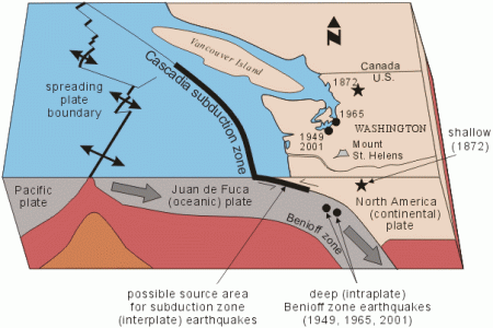
The Cascadia Subduction zone is where the San Juan de Fuca tectonic plate subducts under the continental tectonic plate. It is capable of very large earthquakes (magnitude 9.0 or greater).
Tim Walsh, a geologist for DNR and the state's Chief Hazards Geologist, described to Orcas Island residents the potential impact that a large earthquake and resulting tsunami might have on the San Juan Islands, the Islands Sounder reported today. Walsh was asked to speak at a community information event conducted by the San Juan County Department of Emergency Management. Read more…
If you want to see how areas of your county would fare in a large earthquake, check out DNR's Liquefaction Susceptibility and Site Class Maps of Washington State, by County. This statewide reconnaissance map shows the areas most susceptible to liquefaction — where water-saturated soil loses strength in an earthquake.
Another resource is the Washington Interactive Geologic Map
--
Vei8-Volcanoes of the World Webcams
Roxxfoxx~~Adventures in Geology
Penguin News Today
Penguinology: The Science of Penguins
Gentoo Penguins of Gars O'Higgins Station, Antarctica
Canis lupus 101
Dances with Werewolve
Through Golden Eyes
__._,_.___
No comments:
Post a Comment